


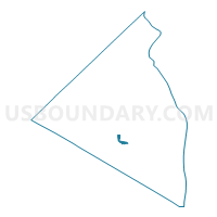
Voting District 010021, Rockland County, New York
About
Outline

Summary
| Unique Area Identifier | 636249 |
| Name | Voting District 010021 |
| County | Rockland County |
| State | New York |
| Area (square miles) | 0.30 |
| Land Area (square miles) | 0.30 |
| Water Area (square miles) | 0.00 |
| % of Land Area | 99.85 |
| % of Water Area | 0.15 |
| Latitude of the Internal Point | 41.11561130 |
| Longtitude of the Internal Point | -74.03932390 |
Maps

Graphs
Select a template below for downloading or customizing gragh for Voting District 010021, Rockland County, New York


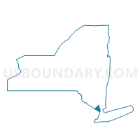
Neighbors
Neighoring Voting District (by Name) Neighboring Voting District on the Map
- Voting District 010010, Rockland County, NY
- Voting District 010035, Rockland County, NY
- Voting District 010044, Rockland County, NY
- Voting District 010080, Rockland County, NY
- Voting District 040012, Rockland County, NY
- Voting District 040013, Rockland County, NY
- Voting District 040042, Rockland County, NY
Top 10 Neighboring County Subdivision (by Population) Neighboring County Subdivision on the Map
Top 10 Neighboring Place (by Population) Neighboring Place on the Map
Top 10 Neighboring Unified School District (by Population) Neighboring Unified School District on the Map
Top 10 Neighboring State Legislative District Lower Chamber (by Population) Neighboring State Legislative District Lower Chamber on the Map
Top 10 Neighboring State Legislative District Upper Chamber (by Population) Neighboring State Legislative District Upper Chamber on the Map
Top 10 Neighboring 111th Congressional District (by Population) Neighboring 111th Congressional District on the Map
Top 10 Neighboring Census Tract (by Population) Neighboring Census Tract on the Map
- Census Tract 113.01, Rockland County, NY (7,348)
- Census Tract 115.04, Rockland County, NY (7,333)
- Census Tract 123, Rockland County, NY (6,127)
- Census Tract 113.02, Rockland County, NY (5,486)
- Census Tract 124.02, Rockland County, NY (5,258)